Total Time & Distance:
2 hours, 22 minutes / 58.2 miles
11 minutes / 6.2 miles to the next bridge
• Head north on Rt. 32 / River Road (4.8 mi)
• Turn left onto Aquetong Road (0.4 mi)
• Turn left onto Covered Bridge Road (1 mi) to...
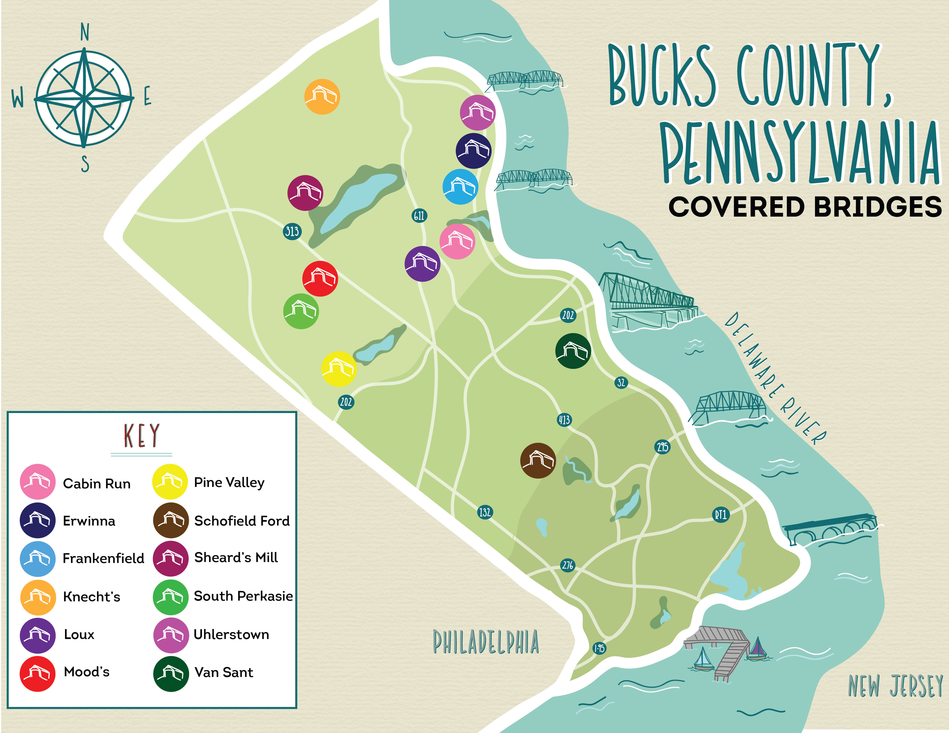
VAN SANDT COVERED BRIDGE
266 Covered Bridge Road, New Hope
26 minutes / 13 miles to the next bridge
• Head north on Covered Bridge Road toward Pidcock Creek Road (1 mi)
• Turn left onto Aquetong Road (7.6 mi)
• Turn left onto Carversville Road (300 ft)
• Make a quick right onto Carversville Wismer Road. After 0.1 mi the road becomes Wismer Road. Follow it for 4.3 mi and after a sharp left turn over Cabin Run Creek you will see...
LOUX COVERED BRIDGE
6303-6329 Carversville Road, Pipersville
5 minutes / 2.1 miles to the next bridge
• Head northwest on Carversville Road/Wismer Road. Continue to follow Carversville Road (0.5 mi)
• Turn right on Dark Hollow Road (0.9 mi)
• Turn right on Covered Bridge Road (0.6 mi), and on your left will be the foot-traffic-only bridge known as...
CABIN RUN COVERED BRIDGE
6083-6209 Covered Bridge Road, Pipersville
8 minutes / 4.3 miles to the next bridge
• Head northwest on Covered Bridge Road (0.6 mi)
• Continue north on Dark Hollow Road (stay right, the road turns into Dark Hollow Road, then East Dark Hollow Road) (3.1 mi)
• Turn left onto Cafferty Road (0.6 mi)
• Turn right onto Hollow Horn Road and in 148 feet you'll see...
FRANKENFIELD COVERED BRIDGE
Hollow Horn & Cafferty Roads, Erwinna
6 minutes / 2.7 miles to the next bridge
• Continue northeast on Cafferty Road (0.2 mi)
• Turn right on Hollow Horn Road (1.3 mi)
• Turn right on Headquarters Road, then make a quick left in 420 feet to continue on the road (0.9 mi)
• Turn left on Geigel Hill Road by the Post Office and in 0.2 mi you will be at...
ERWINNA COVERED BRIDGE
87 Geigel Hill Road, Erwinna
5 minutes / 2.5 miles to the next bridge
• Head south, back towards the Post Office on Geigel Hill Road. It will turn into Headquarters Road (0.5 mi)
• Turn left onto Rt. 32 North / River Road (1.7 mi)
• Turn left onto Uhlerstown Hill Road and in 0.3 miles you'll see...
UHLERSTOWN COVERED BRIDGE
9 Uhlerstown Hill Road, Upper Black Eddy
27 minutes / 13.2 miles to the next bridge
IMPORTANT NOTE: Uhlerstown Hill Road west of the bridge is a one-way road and is closed from December through April. If you're stuck, trace your steps back to Erwinna Covered Bridge. Go through Erwinna Covered Bridge, heading northwest on Geigel Hill Road. Turn right on Tinicum Church Road. Make a left on Perry Auger Road and pick up at the directions below towards Knechts Covered Bridge!
• Drive through the bridge and turn right on Uhlerstown Hill Road (0.8 mi)
• Turn a quick left onto Upper Tinicum Church Road, followed by a quick right onto Perry Auger Road
• (Pick up here if turned around). Continue on Perry Auger Road (1.4 mi)
• Take a right onto Old Forge Road (the road will turn into Lodi Hill Road) (0.9 mi)
• Turn left onto Lonely Cottage Road (0.2 mi)
• Turn right onto Lake Warren Road (2.6 mi)
• Turn left onto Center Hill Road (0.4 mi)
• Cross over Rt. 611 / Easton Road onto Church Hill Road. Continue straight (1.5 mi)
• Turn right onto PA-412 North / Durham Road (3.4 mi)
• Turn left onto Slifer Valley Road (1.8 mi)
• Turn left onto Knecht Bridge Road and in 233 feet, arrive at...
KNECHTS COVERED BRIDGE
2500 Slifer Valley Road, Riegelsville
13 minutes / 7.6 miles to the next bridge
• Return to Slifer Valley Road, turning left (opposite of the way you came) (1.2 mi)
• Turn left onto Rt. 212 / Old Bethlehem Pike (1.1 mi)
• Keep left onto Old Bethlehem Road (4.4 mi)
• Turn right on Thatcher Road (0.5 mi)
• Turn left on Covered Bridge Road and in 0.3 miles, arrive at...
SHEARD'S COVERED BRIDGE
8000 Covered Bridge Road, Quakertown
12 minutes / 6.6 miles to the next bridge
• Continue through the bridge to Richlandtown Road (0.6 mi)
• Turn left on Sterner Mill Road (325 ft)
• Turn right on Mountain View Drive / PA-563 South (0.9 mi)
• Turn left onto Dublin Pike / PA-313 East (1.7 mi)
• Turn right onto N 5th Street (0.9 mi)
• Turn left on W Schwenkmill Road (0.3 mi)
• Turn right onto Branch Road (0.9 mi)
• Turn right onto Blooming Glen Road and in 351 feet come to...
END: MOODS COVERED BRIDGE
After 1200 Branch Road, Perkasie
Head through the bridge north on Blooming Glen Road, make a left on N 5th Street and you're in downtown Perkasie! Explore the shops, restaurants, and nearby attractions like Pearl S. Buck House, Peace Valley Lavender Farm, or the Sellersville Theater. Or, continue on to the Western Loop to complete seeing the rest of the covered bridges.


